
What is this? The Location page shows where your boat is on a map and lets you set its home port.
The Basics
The page has up to three tabs:
- Map — the boat’s position, sent by its YachtLINK® device.
- Home Port — the spot where the boat normally stays. Anyone can set it, with or without YachtLINK®.
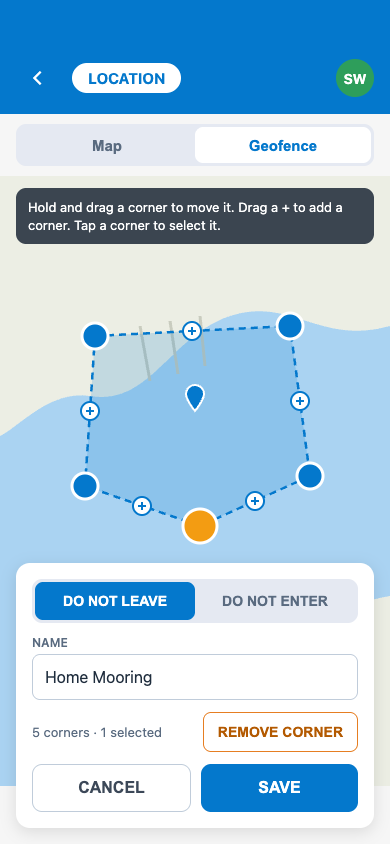
- Geofence — zones you draw on the map to watch for the boat leaving an area, entering an area, or going too fast in one. YACHTWAVE records when the boat crosses a zone, but doesn’t send a notice yet.
If the boat has a registered YachtLINK® device, the page opens on Map. If not, it opens on Home Port, and the Map and Geofence tabs describe what YachtLINK® adds, with ORDER NOW. On an organization’s boat, your organization can hide the Map or Geofence tab.
Key Things on This Screen
- The boat marker — the boat’s last reported position. The map opens showing about 20 miles around it.
- LIVE — shown at the bottom of the map when the position is less than 30 minutes old. Older positions still show, without the LIVE badge.
- Map refresh — while the page is open, the position is checked again every 2 minutes. YachtLINK® itself uploads about every five minutes.
- + / − buttons (top right of the map) — zoom in and out.
- SET / EDIT (Home Port tab) — places or moves the home port pin.
- GPS button (Home Port and Geofence tabs) — centres the map on where you are now. It does not move any pin or zone.
- Zone colors (Geofence tab) — blue solid outline = Permitted (watches for the boat leaving it), red dotted = Prohibited (watches for it entering), yellow dashed = Speed (watches for it going faster than your limit inside it), gray = no alert type set.
- + button (bottom right, Geofence tab) — draws a new zone. The zoom-to-all button (top right) fits every zone on the screen.
- Lock under a zone’s name — the zone is shared across your fleet and can only be changed in fleet management, not here.
How to Set the Home Port
- Open the Home Port tab and tap SET (or EDIT if one is already set).
- Tap the map where the boat normally stays. Hold and drag the pin to fine-tune it. Tap the GPS button first if you are at the berth and want the map centred on you.
- Tap SAVE.
To remove the home port, tap EDIT, then CLEAR, then SAVE. CANCEL leaves it as it was. Leaving the tab before you save drops the unsaved pin.
How to Add a Geofence
- Open the Geofence tab and move the map to the area you want.
- Tap the + button (bottom right). A square zone appears in the middle of the map.
- Shape it: press and hold a corner, then drag it. Tap a + on an edge to add a corner there. Tap a corner, then the − beside it, to remove it (a zone needs at least 3 corners). Press and hold the center handle and drag to move the whole zone.
- Tap the up arrow on the card at the bottom. Enter a Name and choose Permitted, Prohibited, or Speed. For Speed, enter a Limit (a whole number) and pick its unit.
- Tap SAVE (or the check mark).
To change a zone later, tap it, then tap the round pencil under its name. To delete it, open it the same way and tap the red trash can, then confirm; its alert settings are deleted with it.
Tips
- If you cannot see SET or EDIT, or the Geofence +, pencil, or trash can, your access to this boat (or your organization’s permissions) does not allow changes.
- Zones can overlap. A new zone can be drawn over an existing one.
- The GPS button needs location access for YACHTWAVE. If it is off, YACHTWAVE asks you to turn it on in Settings.
Troubleshooting
- “No location for this boat yet” — The boat has not reported a position. It appears once the YachtLINK® device sends one. Check the device’s Last Seen time on the YachtLINK® page.
- “There is no LIVE badge” — The last position is more than 30 minutes old. The boat may be out of Wi-Fi range or without power.
- “Could not get current GPS coordinates” — Your phone could not get a fix. Try again with a clear view of the sky.
- “Edges can’t cross. Move a corner to fix.” — Two sides of the zone cross each other. Drag a corner until the outline no longer crosses itself, then save. While it crosses, the card shows a red Edges Cross line.
- “This geofence is managed by your fleet” — The zone is used on more than one boat. Change it in fleet management instead.
- “The vessel type is required” when saving the home port — The boat has no type set. Set it in the boat’s details, then save the home port again.
Frequently Asked
Do I need YachtLINK® to use this page?
Not for Home Port. The Map and Geofence tabs need a YachtLINK® device on the boat.
How am I alerted when a geofence is crossed?
Alerts aren't sent yet. YACHTWAVE records when the boat crosses a zone, but doesn't send a notice yet.
Is this my phone's location?
No. The marker on the Map tab is the boat's position as sent by its YachtLINK® device. The GPS button on Home Port is the only place your phone's location is used.
How often does the position update?
YachtLINK® uploads about every five minutes. The map checks for a new position every 2 minutes while it is open.
See Also
- YachtLINK® — the device that sends the boat’s position.
- Yacht Dashboard — the tile that opens this page.
- Cruise Log — positions recorded during a trip.